Contents
Index
Job Settings
The Job Settings dialog box allows the user to set the parameters such as the job name,
working directory and background for the job. It can be used either to create a new job
or to edit the settings for an existing job.
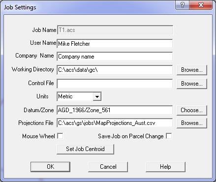
Job Name
The Job Name is the file name used to save the job data on the disk.
User Name
The User Name is recorded in the job for information purposes only.
Company Name
The Company Name is recorded in the job for information purposes only.
Working Directory
The Working Directory is where the files and any other input or output data for this job will be stored.
When a program option allows you to read or write a data file, it will be placed in this directory by default.
Control File
Enter the name of the Control File. This option allows all the control points for a locality
to be held in a file that may cover several parcel ‘areas’.
The file may be the output from a geodetic adjustment or from a GPS system.
The Control files currently supported are csv files.
The program identifies each file type by the filename extension.
If a Control File exists for the job you are creating, you can browse to the file and the control data contained in this file will be used to add coordinates to the control points in the job.
If no Control File exists for the job you are creating, leave this field blank and it can be updated at a later date when a Control File has been created.
Units
Choose the units for the Job from the list, either Metric or USA.
Datum/Zone
Select a Datum and Zone from the list offered.
If the job already contains data, it is not sufficient to simply change the datum
for the job in this dialog box. This option does not transform the job data to the new datum.
You must use Tools/Transform Datum and select the datum to which the data should be transformed.
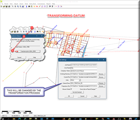
See this topic for more info.
Projections File
This file contains the parameters for Geodetic Datums and Map projections.
The parameters are comma separated and if viewed using a spreadsheet such as Excel,
the headings at the top of the file indicate the data required in each field.
If the first character in a row is a '!' semicolon, the field is treated as a comment.
The two standard files (for Australia and the USA), which you would have received when purchasing GeoCadastre, are: MapProjections_Aust.csv and MapProjections_USA.csv.
See Projection File Format for more infomation.
Mouse Wheel
Tick this box to make the mouse wheel zoom the screen in or out.
If the box is not ticked, the mouse wheel will scroll the screen up and down.
Save Job on Parcel Change
Tick this box to make the program save the data to the job file after every parcel change.
The program will save the job automatically whenever a change has been made to any of the parcels.
Set Job Centroid
This button will select the Job Centroid Menu.
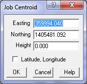
The Job centroid and height can then be entered.
If a centroid exists its coordinates will be displayed.
If the "Latitude/Longitude" box is ticked, the data can be entered as a Latitude and Longitude.